– FROM EURASIA TO AUSTRALIA-OCEANIA—HOW MANY CONTINENTS ARE THERE AND WHERE DO THEIR BORDERS RUN?
Around 70% of the earth’s surface is covered by water. The large landmasses of the earth are called continents. But what defines a “continent,” how many continents are there and where exactly are the borders between them? We give you various possible answers to these questions and explain what division of the continents we use at Marmota Maps .

CONTINENT – DEFINITION
Today’s look of the earth’s surface only shows us a certain point in time during the geological history of our home planet. The continental plates, or lithospheric plates, move at a speed of about 1–10 centimeters per year. The supercontinent named Pangea, where all of the world’s major landmasses were connected, fell apart about 150 million years ago. In the future, the land on earth will continue to slowly change its shape over millions of years, due to the continental drift.
The term “continent” derives from Latin. “Terra continens” can be translated to “continuous land.”
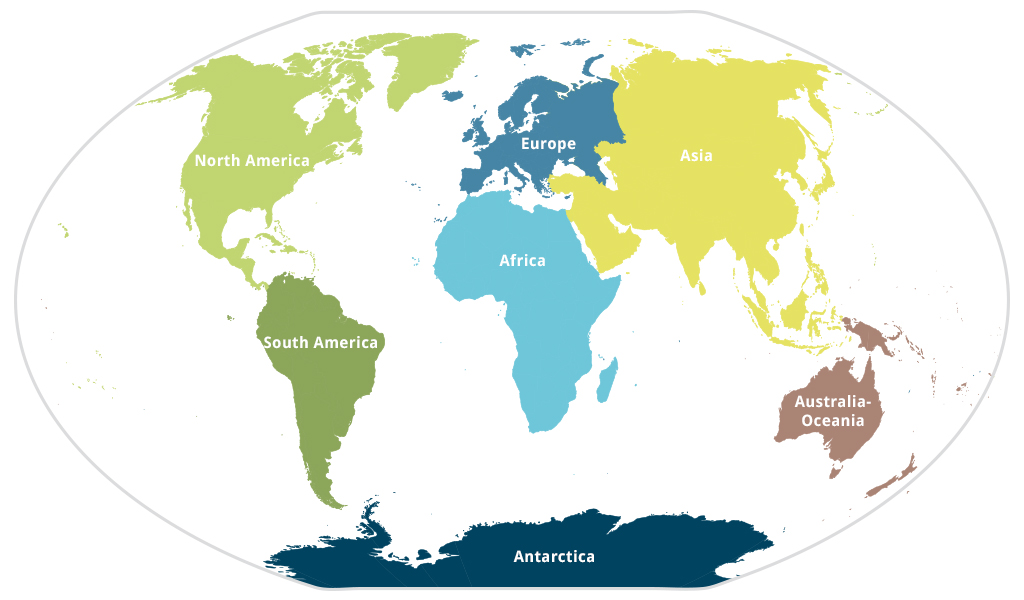
There is no undisputed definition of what constitutes a continent. The Encyclopædia Britannica is frequently cited, which in addition to the definition also specifies the number of continents. Here, a continent is “one of the larger continuous masses of land, namely, Asia, Africa, North America, South America, Antarctica, Europe, and Australia, listed in order of size. (Europe and Asia are sometimes considered a single continent, Eurasia.).”
Other sources sometimes define Australia, the smallest continent, as Oceania or Australia-Oceania.
In general, it can be said that tectonic, geological, geographic, as well as cultural and political criteria are used to classify a continent.
WHICH CONTINENTS ARE THERE?
Usually, the number of continents is considered to be seven, as the Encyclopædia Britannica states. Depending on the point of view though, other numbers between four and eight can be justified, as well.
ANTARCTICA—THE UNDISPUTED CONTINENT
Antarctica is the non-controversial case. The southernmost part of the world, uninhabited by humans, is considered an independent, continental landmass, according to all known definitions. Its borders are largely undisputed.
ONE, TWO OR THREE AMERICAS?
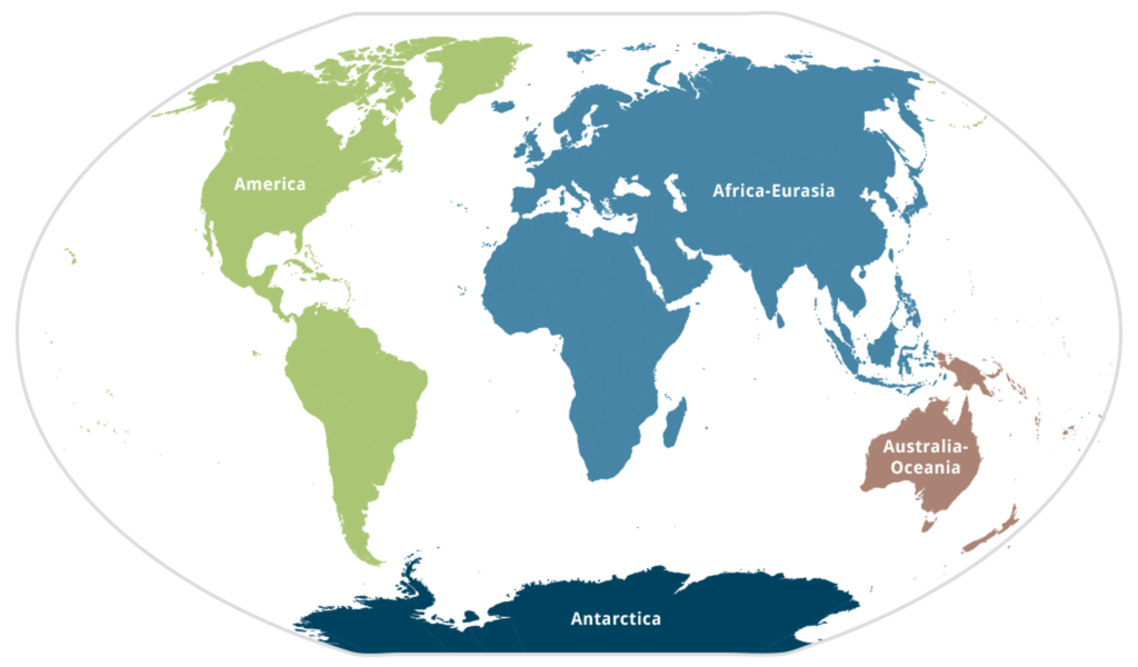
America can be seen as a single landmass. For almost three million years, a land connection from Alaska and the Canadian Shield in the north to Tierra del Fuego in the south has existed. However, the continent is usually divided into North America and South America. Central America and the Caribbean are sometimes seen as another third continent in between.
This division into three parts roughly corresponds with the positions of the continental plates. Ranging from Mexico to Colombia as well as including the Caribbean islands, Central America lies on the Caribbean Plate which is between the North American Plate and the South American Plate. This division of America into three sections can also make sense culturally and geopolitically. At Marmota Maps, we used this division in 2017 for our world map of the surfing regions: „Surfing Worldwide“.
Today, however, we mostly use the division of America into the North American continent including Central America, the Caribbean and all of its islands, and the South American continent with its northern border between Panama and Colombia. This boundary, based on political borders, is a pragmatic solution. Geographically, it would also make sense to draw a border line at the Isthmus of Panama, or along the Panama Canal.
AFRICA
Even though Africa is almost always regarded as a separate continent, there are also arguments for considering Africa, together with Eurasia, as a continuous landmass and, therefore, one single continent. However, it is common to draw a border along the Mediterranean, Suez Canal and Red Sea. The eastern part of Egypt with the Sinai Peninsula is hence usually considered to be part of Asia.
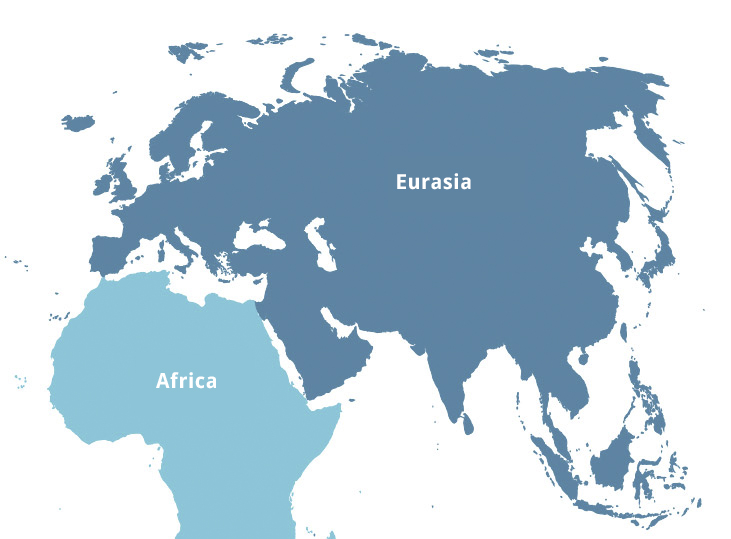
EUROPE OR EURASIA?
Europe is viewed as an independent continent primarily due to cultural and geopolitical reasons. Geologically and geographically, it would make more sense to speak of a Eurasian continent instead. The Eurasian Plate extends from the east of Iceland to the south of Japan. Accordingly, the continental border between Europe and Asia is probably the most controversial.
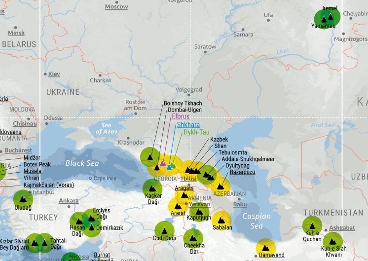
The Ural Mountains and the Ural river in the north are commonly regarded as the border between the two continents. The Bosphorus, which runs through Istanbul, is regarded as the southern border, making the city the only one that is located on two continents. The further course of the border between the Black Sea and western Kazakhstan is particularly disputed, though. This is also of interest for mountaineers. Depending on whether the highest peaks of the Caucasus belong to Europe or Asia, this has an impact on which mountain peak is the continental high point of Europe and thus one of the Seven Summits. Eberhard Jurgalski, for instance, argues that the European–Asian border runs north of the Caucasus along the Kuma–Manych Depression. This would make the Mont Blanc in the Alps the highest European peak. Especially in the mountaineering world, as well as in English- and French-speaking regions, it is more common, though, to draw the border between Europe and Asia along the watersheds of the Caucasus. This makes the Elbrus, located in the Russian part of the mountain range, Europe’s highest peak.
ASIAN BORDERS
The course of the Asian borders is not only controversial in the west towards Europe. The Arabian Peninsula and most of India have their own continental plates. This is why India is often indicated as the Indian subcontinent. However, both areas are almost always considered as parts of Asia. The easternmost part of Russia, as well as the north of Japan is located on the North American Plate. Yet, for geopolitical and geographical reasons, it is obvious that both should still be counted as part of Asia. In the southeast, one can debate about the course of the borders between Asia, Australia and Oceania. Most of the time the Philippines and most of Indonesia are viewed as part of Asia. The island of New Guinea (including the Indonesian part) and Australia, however, are geologically and geographically already part of Australia–Oceania.
AUSTRALIA–OCEANIA–ZEALANDIA
Finally, we are counting Australia–Oceania as the seventh continent. It undoubtedly encompasses the main continental landmass, which largely corresponds to the national territory of the state of Australia. New Guinea, which is also located on the Australian Plate, is additioanly also mostly considered to be part of the Australian continent. There are, however, different views about, whether in addition to the Australian Plate, the Pacific Plate and its islands should also be seen as part of the continent. Some hold the view that only large landmasses should be regarded as continents and that the islands, especially in the Pacific, should be considered as a separate category, so-called “microcontinents”. At Marmota Maps, we regard Australia–Oceania as one continent, including the Pacific Islands from Hawaii to Micronesia.
Since 2014, there has been a debate as to whether Zealandia, a floe between New Caledonia and New Zealand, could possibly be seen as separate continent besides Australia. If further evidence for this view could be found, we might speak of eight continents in the future.